Kohala Watershed Partnership: Bringing Life Back to the Land
By Jan Wizinowich
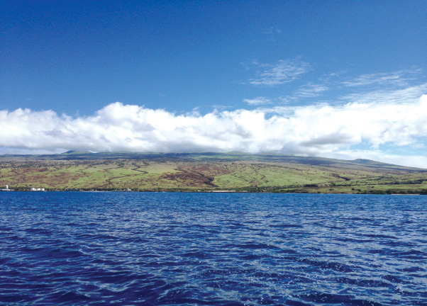
Kohala Mountain stands like a cloud-cloaked monarch, crowned with a 50,000 acre forest that feeds the streams and people of Kohala. The tradewinds bring warm water into the cool mountains and create a constant source of moisture that in pre-western contact time fed the intensive Kohala field system.
Today, Kohala Mountain still provides approximately 6%, or 154 million gallons per day, of the sustainable yield of water for Hawai‘i Island. The watershed is a primary source of drinking and irrigation water for Kohala and parts of Hāmākua, but with an enlarged, restored watershed the potential is much greater.
Recognizing this, the state Department of Land and Natural Resources (DLNR) brought Kohala Mountain landowners and managers together in 2003. “There was a push from the DLNR to look at watershed forest issues on a bigger picture level as a whole,” said Pono Von Holt, owner of Ponoholo Ranch and one of the landowners convened. “Lisa Hadway, who was working within the DLNR, started the momentum. They called a meeting and we found that our goals were in alignment.”
The landowners and managers that formed the Kohala Watershed Partnership (KWP) were Kahua, Parker and Ponoholo ranches, DLNR, Kamehameha Schools, the Department of Hawaiian Home Lands, Queen Emma Land Co., Laupāhoehoe Nui LLC, Surety Kohala, and associate partners The Nature Conservancy (TNC) and the National Oceanic and Atmospheric Administration (NOAA).
The eighth watershed partnership to be formed statewide, KWP consists of approximately 68,000 acres of forest and grasslands on the windward and leeward slopes of Kohala Mountain, the island’s oldest volcano.
The partners agreed that the organization would have a very limited to non-existent bureaucracy while also realizing they needed a coordinator. They brought the Kohala Center onboard, hiring Melora Purell.
“I sat down with each of the partners when I started the job and the key thing I wanted to understand was why they signed on to this,” Melora said. “I was quite blown away by how it was driven by landowners and managers wanting to do what was right, what was pono for the land, the ecosystem, the forest, the watershed.”
One of the first tasks of the KWP was to create a management plan. “The management plan was really clear about what needed to be done, why it needed to be done and how it needed to be done. I had this plan in front of me and I just needed to get to work,” said Melora.
The Kohala Center with its current KWP Coordinator, Cody Dwight, seeks out funding and manages the “boots on the ground” work. “That’s [The Kohala Center’s] forte being an organization that pools together these different programs and facilitates funding, as well as the operation side, so we can pool our goals and our time and effort,” said Pono.

First Steps
Starting at the top, the idea was to extend the forest reserve zone down the mountain by eliminating feral ungulates and installing fencing to create exclosures—fenced areas to protect the forest within. “Take the forest away from the cattle and move them down the mountain. We’re going to increase the size of the watershed by several thousand acres into our ranch country and that will give us a buffer for invasives,” said Pono.
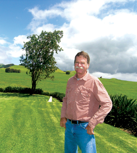
Getting the feral cattle—probably descendants of the cattle gifted to Kamehameha by Captain George Vancouver in the late 18th century—out of the forest was no easy task. Individual efforts by the ranches in the past had not been successful, but united under KWP, Ponoholo, Kahua and Parker Ranches were able to remove all the feral cattle from 1,000 acres of the forest. “We learned our strength just by the fact that we put the three ranches together in a concerted effort,” said Pono.
Fencing is a key component of ungulate control. “The first fence up was on Ponoholo Ranch, about 100 acres. Parker ranch extended from that along the inside of the Honokāne Valley ridge and right in to the edge of Pololū,” said Pono. “By the time we get done we’ll have 3,000 acres that we’ve taken back and in 50 years or so, it will be reforested,” he added.
Pelekane Watershed
The Pelekane Bay Watershed is a graphic example of the importance of a botanically healthy watershed. The Koai‘a Corridor, which is in the upper Pelekane Watershed, runs mauka from Kohala Mountain Road and is a two-mile riparian corridor of about 300 acres nestled between Waiakamali and Luahine streams. Down slope in the lower Pelekane Watershed, the two streams eventually merge into Makeāhua stream which in turn empties into Pelekane Bay.
The watershed needs a layered diversity of plants to capture and absorb the rains. Otherwise sediment-filled water flows down the mountainside and into the ocean. Standing on the Koai‘a Tree Sanctuary fence-line, the contrast is stunning. Inside the sanctuary are groves of koai‘a, large healthy ‘ōhi‘a and lower canopy natives. Outside the fence is a windswept grassland.
Once a canopied forest, the lower Pelekane Watershed is almost completely devoid of vegetation and is severely eroded. “A large portion of the leeward side of this mountain used to look like the Koai‘a Corridor,” said Cody. The consequences of the denuded watershed can easily be seen in Pelekane Bay. Once a biologically diverse estuary, Pelekane Bay has been inundated with sediment washed down the drastically eroded mountainside.
“To protect the coral reef we have to stabilize this mountain from eroding. Get some vegetation to grow in critical erosion areas,” said Cody. The main obstacle to this is a large uncontrolled herd of feral goats that live in the watershed. “The goats live in gulches and they eat the grass from the top and then they go back down into the gulches,” said Cody.
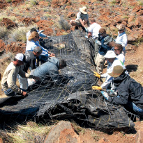
A temporary measure to control erosion while working towards revegetation is the installation of check dams: a wire and cloth-wrapped rock wall, placed in key drainages and capable of holding up to 10 tons of sediment. In August 2015 a large brushfire followed a week later by a brief, intense storm event put those check dams to the test. “It was like a perfect storm event. Those sediment check dams we had in place all filled up,” said Cody.
Changes in water quality are being monitored by TNC and NOAA. “The water quality has improved. Changes in Pelekane Bay. Changes on the landscape. These areas are looking a lot better,” said Cody.
Creating Conditions for Growth
The ultimate goal is to have a re-vegetated watershed, but to do this it is necessary to remove invasive plants and create positive conditions for forest regrowth. Propagating and outplanting, along with fencing, invasive species control and anything else that needs to get done, is the job of the four person KWP field crew.
Crew leader Haia Auwelo, Kukui Keli‘iho‘omalu, Jordon Wills and new volunteer crew member Makali‘i Bertelmann drive up Kohala Mountain Road and enter the Lower Pelekane Watershed. The crew spreads out to survey the area and find several ‘a‘ali‘i with mature seeds, which are collected and will be taken to the State Tree Nursery in Waimea where plants are propagated for future out-planting. “In the Koai‘a sanctuary corridor we have about 60,000 plants already and below we have about 20,000 plants,” said Hai‘a.
When they’re ready to be outplanted, the seedlings are set outside the nursery in a semi-sheltered area and watering is continued. The next step is to take them up to the watershed for planting, where they are sheltered by tall grass and will continue to receive water through a temporary irrigation system fed from water tanks and when established, the plants will stop receiving irrigation.
The Watershed is our Kumu
The Kohala Watershed has become an outdoor classroom and laboratory for Kohala’s children. Along with The Kohala Center’s Ke Kumu ‘Āina program, Mahina Patterson coordinates place-based, hands-on science classes in the watershed. “Because the Kohala Watershed Partnership is housed at the Kohala Center, we have this resource to share with the community,” said Mahina.
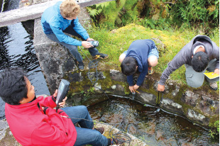
Being in the watershed allows learners to explore independently and make observations. “I ask students: ‘What do you see inside the fenced unit versus the outside landscape?’ We read the story that the land has to tell us,” said Mahina.
Students also get an opportunity to think and act like scientists. “Another great lesson is biodiversity. What are the species here and what are we seeing? They get to experience doing real science using scientific tools,” said Mahina.
The watershed also gives students the opportunity to experience restoration work and to grapple with its challenges. “I was on Pu‘u Pili with a group of Kohala Middle School students, learning about pig trapping and ginger control. It was an opportunity to show them why fences are important. Let’s together look at the effects of the pigs on the forest, do ungulate surveys. Real science,” said Mahina.
The watershed also educates the heart and fosters gratitude. “It’s just so beautiful and so different that even kids that had a bad attitude when they got into the van, when they get there, everything shifts,” said Mahina. ❖
Learn more about the Kohala Watershed Partnership at kohalacenter.org/kwp.
