A Brief History of: Kalalea Heiau
Peter T. Young
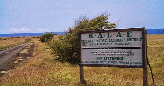
Ka Lae is the site of one of the earliest Hawaiian settlements, and it has one of the longest archaeological records on the islands (included in the complex is the earliest recorded occupation site (124 AD.) (NPS) Ka Lae (Lit., the point, commonly called South Point) on the Island of Hawai‘i is the southernmost point in the fifty states.
Ka‘ū is poetically known as “Ka‘ū kua makani” (Ka‘ū with windy back.) (Soehren) An offshore stone at South Point is called Pokakuokeau (stone of the current) referring to the meeting of the different ocean currents that come together here. (k12-hi-us)
Nā kai haele lua o Kalae, ‘O Kāwili lāua ‘o Hala‘ea
The two sea currents of Kalae —Kāwili and Hala‘ea
The Hala‘ea current (named after a chief,) comes from the east to Kalae and sweeps out to sea. The Kāwili (Hit-and-twist) comes from the west and flows out alongside the Hala‘ea. Woe betide anyone caught between. (Keala Pono)
Here at the point is a heiau, Kalalea Heiau, located in the ahupua‘a of Kamā‘oa. In 1906, Stokes, in describing the heiau, said, “This heiau was … 43 by 35 ft., with platforms outside … adjoining its western wall ….” The heiau complex has a small terraced platform paved with ‘ili‘ili (small, smooth pebbles.) When Stokes visited the heiau, an informant told him that the heiau was Kamehameha’s and was very sacred.
Ten years later another informant told Stokes the following: “(This is the) history of the heiau of Kalalea at Kalae, and of Kū‘ula, Wahinehele and ‘Ai‘ai. Kū‘ula (a male) married Wahine (a female) and they had a son ‘Ai‘ai. They left Kahiki and came to these islands, settling on Kaua‘i. ‘Ai‘ai left his parents on Kaua‘i and went on a sightseeing tour to the islands of O‘ahu, Moloka‘i, Maui and Hawai‘i.”
“When he reached Kalae, he looked around and saw that it was a fine country, and a nice place to live in and well supplied with fish. He returned to Kaua‘i and brought his parents back with him, and they all lived at Kalae. While his parents were living at Kalae, ‘Ai‘ai set out for Kahiki and brought back many people—kilokilo (seers,) kuhikuhipuuone (architects who made plans in the sand), and ai pu‘upu‘u (stewards).”
“He also brought back many different kinds of food, such as breadfruit, bananas, awa, cocoanuts, sugar cane, sweet potatoes, kalo, papaya, hapu‘u and pala (both edible ferns) and other foods in great quantity.”
“And when ‘Ai‘ai saw that the food and the men were ready, he gave commands to all the Menehune and the erection of the heiau went on until the walls were completed. It was named Kalalea, which name still stands today.” Today, people reference Kalalea as a fishing heiau. There were stones that represent the fishing gods Kū‘ula and ‘Ai‘ai.
On the main platform is a stone called Kumaiea (female), but also attributed to Kāne, and on the smaller platform just mauka is another upright stone called kanemakua (male), associated with the god Kanaloa. Standing twelve feet to the north of the heiau are two more stones, the northerly one called ‘Ai‘ai, the son or Kū‘ula. Within the heiau, beside the mauka wall, is a rock called Kū‘ula, the god of fishermen. (k12-hi-us)
In 1953 Emory obtained the following information from Mary Kawena Pukui: “One must not wear red on the beaches at Kalae where Kalalea Heiau is located. Women never went inside the heiau. The kū‘ula of this heiau is a shark. It is a heiau ho‘oulu (to increase) opelu (mackerel), malolo (flying fish), and ahi (tuna).”
Directly seaward of Kalalea Heiau is a rough ledge of lava, with low cliffs dropping into the ocean. About eighty holes (like cleats) are carved into the lava to moor canoes (either for positioning over fishing grounds or to tie-up to shore.) (Kirch) While many have suggested the heiau is fishing related, it appears to also have links to navigation.
Immediately behind the heiau is a modern navigational beacon. First proposed in 1883, a lens-lantern supported by a 34-foot wooden mast was ready for display on March 5, 1906. Its light, visible for nine miles, was produced by incandescent oil vapor.
After several modifications and improvements, the present 32-foot concrete pole was built in 1972. The automated, battery powered light is charged by solar panels.
In at least the 1940s and early-1950s, the military had a landing facility, Morse Field, in this area. There was limited infrastructure; the planes landed/took off on the grassy runway.
At a recent lecture at Mission Houses, I heard another series of stories related to Kalalea Heiau, told by John Laimana (a descendent of the area, whose family has direct association with the heiau;) while similar to much of the other explanations, he expands upon the navigational aspects of the heiau to Kahiki (Tahiti) and Rapanui (Easter Island.)
John says the heiau is actually the smaller of the structures there, makai of the larger, stonewalled rectangle (the larger he says is a fishers’ shelter.) More importantly, he notes that the heiau structure aligns east and west—and one wall aligns with magnetic north.
Equally more important, he looks beyond the heiau structure and also looks at the larger surrounding perimeter wall structure. Careful review of that shows the two walls are in precise, straight alignment.
OK, here’s another overlooked feature … extending the alignment of the walls, thousands of miles across the ocean lead you to Maupiti (in French Polynesia, near Tahiti) and Rapanui (Easter Island, Chile.)
In Hawaiian, Panana means compass, especially a mariner’s compass. Panana are also referred to “sighting walls.” The alignment of the walls (within the heiau and the perimeter walls,) may have been used for navigational purposes.
Oh, one more thing … Ka‘ū is an ancient name with similar derivations in Samoa (Ta‘ū) and Mortlock (Marqueen) Islands (Takuu; an atoll at Papua New Guinea.) (Pukui) (This heiau may have links across the extent of the South Pacific.) ❖
Connect with Peter: ToTakeResponsibility.blogspot.com
Peter T. Young
Peter T. Young grew up on Kāne‘ohe Bay, lived for 28 years in Kailua-Kona and Waimea on Hawai‘i Island, then returned back to O‘ahu where he lives in Kailua. He is President of Hoʻokuleana LLC (to take responsibility) and a lover of history of the Hawaiian Islands. Ke Ola is honored to have him share his historical findings with our readers.