Look For The Helpers: How Hawaii Tracker Became a Pivotal Community Resource
By Denise Laitinen
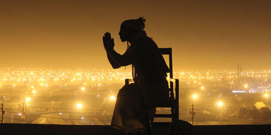
Mr. Rogers, the beloved children’s TV show host, is known for saying, “When I was a boy and I would see scary things in the news, my mother would say to me, ‘Look for the helpers. You will always find people who are helping.’” If Mr. Rogers were still alive, he would have found those helpers in the form of the Hawaii Tracker Facebook group, a team of volunteers who worked tirelessly around the clock for months to help their community during last year’s Kīlauea eruption.
Hawaii Tracker’s roots go back to 2014 when Ryan Finlay created the group as a community resource when lava from Pu‘u ‘Ō‘ō was threatening Pāhoa in 2014. “I was a writer and blogger and had experience with community building online through a blog I wrote called Recraigslist.” Given his background, Ryan says it was a no-brainer to help the community by creating the Hawaii Tracker group. He provided updates, fact checking information, and sharing official updates from various government agencies.
2018 Eruption
The ground started shaking in Leilani Estates in early May 2018 with hundreds of earthquakes in the magnitude two range within a two-day span. Ryan looked at where the earthquakes were originating and studied maps from the 1955 Kapoho eruption. Based on his research and information being publicly posted by USGS, Ryan created a map a day before lava started coming out of the ground, predicting where he thought lava might erupt. In hindsight, he was incredibly accurate predicting the path of 24 fissures that erupted in the coming months.
In the face of the unprecedented eruption, with scant information available, many in the community and around the world turned to Hawaii Tracker. Ryan went into overdrive, providing multiple updates a day. Initially, he was doing all the work himself, researching, posting, and moderating comments, and quickly realized he needed help.
The Hawaii Tracker Helpers

The work of the volunteer group, many of whom did not know each other prior to the eruption, is a testament to the spirit of community collaboration. It grew organically. “People with all different skills from photographers, weather modeling, mapping, writing daily reports, they were all wanting to help. It’s an incredible team of helpers. It’s a lot like a newspaper or a TV station with different people contributing,” says Ryan.
While many have contributed to Tracker, the core team includes Ryan, Andrew Hara, Dane duPont, Ken Boyer, Sarah Wilkinson, Les Pedersen, Philip Ong, and Harry Durgin.
Photographer Andrew Richard Hara provided constant photo updates as events unfolded in Leilani. Harry Durgin, co-founder the Puna Weather Facebook group, provided information analyzing the lava’s impact on localized weather and trade wind patterns, since area residents were concerned about which way the hazardous volcanic gases were blowing.
While lava was spewing out of the ground in lower Puna, 20 miles away the community of Volcano was experiencing roughly 100 daily earthquakes and ash eruptions due to activity at Halema‘uma‘u crater.
Ken Boyer, a photographer who has lived in Volcano nearly his entire life, had never heard of Hawaii Tracker until he started livestreaming videos of the ash eruptions taking place near his home. Ryan reached out to Ken after seeing the videos and Ken was soon providing regular updates to the Tracker audience.
“Being part of Tracker helped me have some resources in the field,” explains Ken. “We are a team, anything we can do to help each other, we do. If we need something verified while out in the field, someone can and will do that immediately. It’s amazing.”
Sarah Wilkinson had been following Tracker since its early stages and was impressed with how well-moderated the group was, as well as Ryan’s ability to provide timely and accurate information. At the time of the eruption, she and her family lived in Leilani. She quickly became glued to the Tracker group for updates and information. Sarah, who manages an office for a local archeological firm, realized she had skills that could help the group.
“I appreciated how Tracker was helping me personally, and wanted to support Ryan’s efforts however I could in return,” she says. “The more I became involved, the more I realized that helping Tracker was helping me cope with my personal eruption experience.”
Meanwhile Philip Ong, who has a master’s degree in geology, helped provide insights and explain updates from USGS and other organizations. Philip had lots of experience providing presentations on volcanic eruptions from his days leading educational groups, after his days as a volunteer with the Hawaiian Volcano Observatory. He started giving detailed video reports on a nightly basis, first at the Hub in Pāhoa and then on the Hawaii Tracker page. Since he didn’t have to condense material to fit in a newscast or short post, Philip could relay information in detail during his video reports and spend time patiently answering questions from people around the world.
Les Pedersen and Dane duPont brought their mapping skills to the Tracker team. Les had been involved with Tracker since the 2014 lava threat. Dane, who still lives with his family in Leilani, has an extensive background in computer science and GIS mapping combined with military experience. Mike Purvis, a mutual friend of Ryan’s who attended the University of Hawai‘i at Hilo with Dane, introduced Dane to the Tracker group.
An Orchestrated Effort
With so many people contributing various skills, the Hawaii Tracker team was able to provide updates few other organizations could.
For instance, in the early weeks of the eruption, lava inundation maps showing how many homes were destroyed were not readily available from governing agencies. Dane was able to pull together publicly available property tax records and combine that information with lava flow maps from USGS. So good were Dane’s maps that federal and state officials used them as part of their justification for requesting aid.
With their resources, the Tracker team could report in real time. When lava overtook the seaside community of Kapoho, the Hawaii Tracker team was able to report what homes had been lost. Dane and other tracker members had already pulled publicly available data from the County Real Property Tax Office. Professional photographers Mick Kalber (a Leilani resident) and Bruce Omori, both well known for their lava photography, provided aerial footage confirming where the lava had flowed. Combining all the information together, they documented how many homes had been lost as the event was unfolding.
A Calm and Civil Resource
With emotions running high and media outlets reporting inaccurate information on a national and international level, providing a safe platform where information was not overstated was a challenge.
Ryan points out that the group was particularly careful not to sensationalize what was happening. “It would have been easy to sensationalize to get those extra clicks, but we never went that route. If anything, we understated things.” Dane adds, “We [still] don’t raise the flag very often about something really bad happening. When the warning flag is raised, it means something.”
“We were getting 100–300 post submissions a day,” chimes in Ryan, “and 1,000 new followers daily. It was a time-consuming effort,” he adds. “We spent an enormous amount of time looking into every single submission, or did the research ourselves. For example, Sarah spent hours researching topics behind the scenes. She was a huge help and support.” People took notice of their work. It took four years for Ryan to grow the group to 4,000 members from 2014 to April 2018 and just a few months after the eruption for it to grow to more than 51,000 members.
Tracker’s work in community engagement even caught the attention of Facebook itself, which sent a film crew to Puna to film Hawaii Tracker’s efforts. In February 2019 Hawaii Tracker was one of a few Facebook groups from around the world to receive a coveted invitation to attend the prestigious Facebook Communities Summit at Facebook’s national headquarters. In April, the group was recognized by the Big Island Press Club, receiving the Club’s first-ever Excellence in Media Innovation award.
Hawaii Tracker’s Future
Now that the eruption is over, the Hawaii Tracker team is charting their next stage of evolution. Ryan is exploring various models to expand Tracker while ensuring it is financially viable. By working with local businesses for advertising and receiving contributions from members, “we are building an entire Tracker platform to enable local news and information communities to pop up all over the place,” explains Ryan.
“The world happens in real time and it’s reported that way now,” says Ryan. Yet many parts of the country are in what’s called “news deserts,” with no local news outlets. “Given Puna’s size and the number of people who live out here, most towns of a similar size on the mainland would have their own newspaper,” explains Ryan.
Dane adds, “As someone with a computer science background, what we did is impressive, but compared to what is out there…we are still at the surface of real time information sharing and what’s possible.
“We’re now in algorithmic age of information technology where you constantly have to adapt and…if you are not keeping pace with it, you get left in the dust. Nothing shows that more than when a disaster happens, because when a disaster strikes, you don’t have time to put new technology and processes in place.” ❖
For more information: Facebook.com/HawaiiTracker, hawaii.jointracker.com
Denise Laitinen
Hailing from Cape Cod, Massachusetts, Denise has called Hawai’i home since moving to these islands in 1994. With a writing career spanning more than two decades, Denise is a regular contributor to Ke Ola publications and her work appears frequently in newspapers, magazines, and websites around the country. Passionate about sharing the stories of the people and history that make Hawai’i so unique, Denise’s motto is, “because people’s stories deserve to be told.” Denise is also a sought-after social media instructor who provides social media training for government officials, corporate leaders, and small business owners. Active in the community, Denise was nominated as Hawai‘i County Woman of the Year in 2009 and has served as president of the Big Island Press Club, as well as on the board of directors for the Social Media Club Hawaii. An ardent pet lover, she lives on the slopes of an active volcano in lower Puna with her cats and dogs.