Then & Now: Puako—A Resilient, Ocean Focused Community
By Pete Hendricks
Puako, on the northwest coast of Hawai‘i Island, had been a fishing and salt producing settlement centuries before the arrival of Captain James Cook in early 1779. When Cook left Kealakekua Bay to continue his ill-fated third voyage, he intended to explore the remainder of Hawai‘i’s west coast and Maui before heading north to search again for the Northwest Passage through North America. Cook’s ships, Resolution and Discovery, also carried Hawaiian passengers bound for Maui. One of the men, Koa, told Cook that water and shelter could be found in Kawaihae Bay.
Cook sent Lt. William Bligh, later Captain Bligh of the famous Bounty mutiny, ahead in the pinnace, an open boat powered by oars and sail, to reconnoiter. Bligh was probably in the area between Anaeho‘omalu Bay and Kawaihae, where he found no significant water or shelter. Bligh, however, did experience the fierce, mumuku winds, which sweep over the Waimea plains and accelerate down the slopes to the sea. Puako residents surely saw Cook’s ships. On his way back to the Resolution, it is recorded that Bligh and his crew rescued three Hawaiians whose canoe had been overwhelmed by the winds and seas. In a spell of fierce mumuku, Resolution sprung her foremast and Cook made the fateful decision to return to Kealakekua for repairs.
The Hawaiian residents of Puako, meanwhile, were surviving as they had for many generations, obtaining their meager water supplies by drip-collecting systems in caves, small springs and anchialine ponds of brackish water with a tidal connection to the ocean. The name Puako is connected to the story of a Hawaiian princess of the same name and her lover, Lalamilo. “Puako” can mean either “the tassel of the sugar cane” or “the flower of the Kou tree.” One of the most extensive fields of petroglyphs in Hawai‘i attests to the resourcefulness and longevity of the Hawaiian presence at Puako.
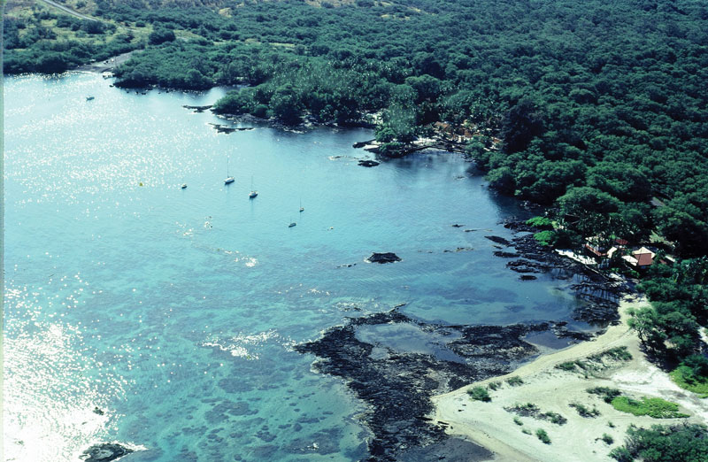
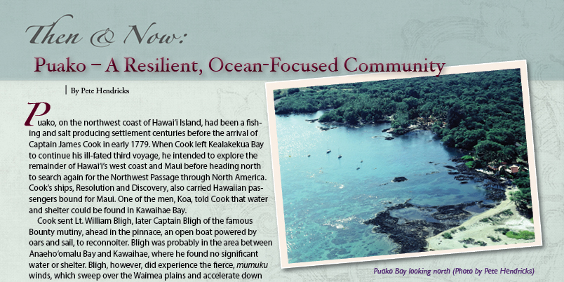
In the early days of Puako, between Puako Bay and the south end of the present Puako Beach Drive at Paniau, there was likely little food cultivation. The reef fronting Puako is unique for the island in its extensive reef flats with spur-and-groove, underwater formation and a healthy community of coral, fish, and invertebrates. Coconuts have also been a valuable asset, and the inhabitants traded fish and limu (algae) with uplanders for staples such as taro and sweet potato.
Puako Hawaiians were probably drafted to help reconstruct Pu‘ukohola Heiau for Kamehameha I in 1791. Soon after, many inhabitants of the whole region were harvesting and carrying sandalwood from nearby leeward slopes down to waiting ships for the new export industry. The first visit of a whaling ship to Hawai‘i, the Balena in 1819, brought a new industry which was to dominate the economy of these islands until the mid 1800s.
In 1835, the beloved Reverend Lorenzo Lyons described Puako after walking there from Waimea: “Puako is a village on the shore, very like Kawaihae, but larger. It has a small harbor in which native vessels anchor. Coconut groves give it a verdant aspect. No food grows in the place. The people make salt and catch fish. These they exchange for vegetables grown elsewhere.” Lyons dedicated Puako’s Hokuloa Church in 1860.
Influenza, measles, and smallpox devastated local populations at mid-century. Madam Pele was at work too. A massive lava flow from Mauna Loa reached the ocean south of Puako in 1859, traveling between today’s Mauna Lani and Waikoloa Resorts. The smoke from the flow was easily visible from Puako, and the lava and its residue killed much of the marine life on nearby reefs.
Puako continued relatively unchanged toward the end of the 1800s, until the coming of commercial sugar cultivation. Sugarcane had been one of the plants brought to Hawai‘i by the Polynesians from the south. In 1895, Wilmot Vredenberg discovered some fine-looking sugarcane on a trip through Puako. Vredenberg showed the cane to R.R. Hind, who decided to expand his North Kohala sugar production there. The Hinds acquired a piece of land from Parker Ranch, which had used Puako for winter cattle forage and occasional shipping of cattle from the bay. The sugar plantation grew to include the wharf (whose pilings can be seen just south of the present boat launch ramp), a piece of shoreline and much of the current kiawe forest east of present Puako Beach Drive.
Puako Plantation grew to include a processing mill, dormitories and camp for about 300 workers, a store, office building, warehousing and a honey operation. A small railroad brought sugarcane to the mill. Like many landings in Hawai‘i, small ships could come into Puako Bay, but even-smaller vessels had to carry the bags of sugar out from the little wharf. The freighter Humu‘ula, still remembered by some old-timers here, later called at Puako.
In 1897, R.R. Hind had the beautiful steam sailer Upolu built in Alameda, California, to service the Hind coastal enterprises and Honolulu needs. The Upolu was 86.5 feet long with a beam of 18.8 feet. The little coastal and interisland steamer was a great success. Unfortunately, Upolu met her end on April 2, 1901 in Puako Bay, in good weather, under the command of a captain unfamiliar with the reef. Upolu struck hard on her approach into the bay and was a total loss.
Puako is the ocean entry for a huge watershed, stretching hundreds of square miles up the Mauna Kea slopes. Winds, persistent drought and rare flooding eventually doomed Puako Plantation. Production declined from 835 tons of sugar in 1909 to 185 tons in 1913.
An outgrowth of the sugar operation was honey production, which was taken over by the Goto family when the mill closed. By the late 1930s, the operation shipped more than 500 five-gallon containers of honey annually.
Another shipwreck occurred at Puako Bay in the early 1930s, involving a Swedish ship, one of several transporting honey to U.S. and Swedish ports. Occasional cattle grazing and various commercial crops, such as cotton and tobacco, came and went over the years until 163 Puako houselots were developed in the early 1950s. Today a mix of modest, original cottages and substantial homes make up the Puako community. Puako continues to be an important ocean entry for small boats, with a few moored in the bay and most launched daily from the state launch ramp.
Just to the north of the launch ramp is the five-acre future home of Kalākaua Marine Education Center (KMEC), a planned UH Hilo marine laboratory. QUEST (Quantative Underwater Environmental Survey Techniques), a popular course which attracts students from Hawai‘i, mainland and international institutions, will be taught at KMEC. KMEC is planned as a community-friendly research and education center.
The Puako community has always been ocean-oriented and in modern times has contributed funding to ocean water quality monitoring and management. The small, resilient community of Puako is committed to maintaining the health, productivity and resiliency of the unique ocean ecosystem it shares.