To Seek Far: ‘Imiloa Astronomy Center Reaches Out to Students of All Ages
By Stefan Verbano
“So, what’s one way we can tell the age of a volcano?” Punawai Rice asks the audience of fourth graders seated before him. No hands shoot up. “Well think about this: how can we tell one volcano is older than another?” More fidgets and befuddled looks.
Punawai negotiates the video game controller in his hands, and three interlinked flatscreen televisions behind him are set ablur with color and movement as the aerial view of a 3D-rendered Hawai‘i Island and its five volcanoes—Maunakea, Maunaloa, Kīlauea, Hualālai, and Kohala—becomes superimposed with name markers. Using the controls, he soars north across the island, zooming in on the million-year-old Kohala Mountain and the long, skinny notches cut out of its eastern flank: Hāmākua Coast’s seven majestic valleys, including Waipi‘o, Waimanu, and Pololū.
“How do we know Uncle Punawai is older than all of you?” the guide starts a hint, hovering the controller over the valleys. A kid in the back row pipes up: “No hair!” “Yes, thankfully I’ve still got all my hair,” he jests, rubbing his scalp with a smirk, and the group bursts into giggles.
“How else do we know I’m older?” he eggs them on, setting the controller down and lifting both of his open palms up to his head, running fingertips across his face, drawing imaginary lines. “Wrinkles!” some of the kids yell excitedly. They’ve got it now. “That’s right!” he hollers back, motioning toward the interlinked screens behind him. “These are wrinkles made over many, many, many years.”
The picture zooms in on the sharply detailed model (think Google Maps times a hundred) until Waipi‘o Valley’s deep, tapering profile takes up all three screens. Then the perspective morphs again, sinking from a bird’s-eye view down into a side-profile of the valley, as if the viewer were now peering over the railing of a tour boat anchored just offshore of where Wailoa Stream meets the ocean.
“What can carve out rock like that?” Punawai asks the students, climbing up the valley now with his joysticks, panning side to side to show the sculpted green cliffs of eroded rock. “A pickaxe?” another would-be interloper in the back suggests. The group giggles harder this time. A girl raises her hand. “Erosion?” she offers, more confidently. “Yes, but what causes the erosion?” he drives the point home at last. In an instant faces light up, and the whole group howls out together: “Water!”
These students from ‘Ele‘ele Elementary School on Kaua‘i are sitting in ‘Imiloa Astronomy Center’s CyberCANOE—a miniature theater set back from the center’s 12,000 square foot exhibit hall—where instructors like Punawai manipulate data visualizations on the split screens and seemingly transport CANOE passengers inside, above and beyond Hawai‘i Island, to exotic, far-flung places in Polynesia, other continents on Earth, and even out into deep space.
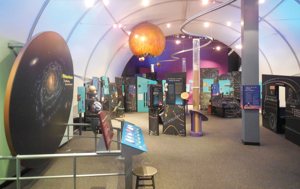
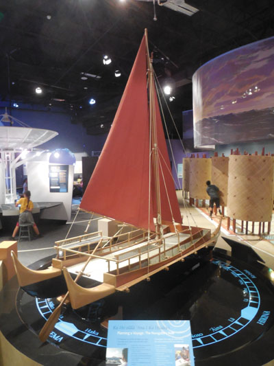
CANOE stands for Collaborative, Analytics, Navigation and Observation Equipment, which uses data from research findings conducted within the University of Hawai‘i community and in various scientific industries to create visualizations depicting everything from coral reefs to volcanoes, river systems to solar systems. It’s just one of the many high-tech, world-class interactive learning tools found at the nine-acre ‘Imiloa Astronomy Center campus, located in the University of Hawai‘i at Hilo’s Science and Technology Park. In Hawaiian, ‘Imiloa means “to seek far,” and is used to refer to both “explore” and “explorer.”
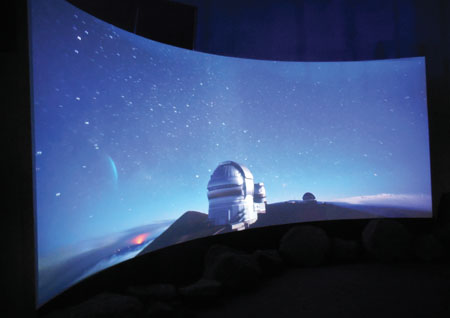
The $26 million center opened its doors in early 2006. It’s the brainchild of a team of educators, scientists, and community leaders who saw the need for a comprehensive educational facility attached to the university to help enlighten the public about how traditional Hawaiian culture, Polynesian open ocean navigation, and space exploration research being done atop Maunakea all intersect. In addition to the exhibits, ‘Imiloa has a 120-seat planetarium featuring a full dome video projection system offering K–12 field-trippers, freshman astronomy students, and everyone else a chance to recline and take a guided tour of the cosmos.
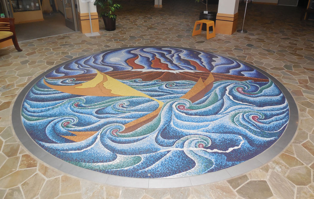
Roughly 100,000 visitors every year, including 10,000 primary and secondary school students, walk across artist Clayton Bryant Young’s giant glass tile mosaic installation, entitled Voyage of the Navigator, found just inside ‘Imiloa’s front doors. Some are held spellbound for a moment staring at the floor, at a scene of churning ocean, charging canoe, shining moon, steaming snow-topped mountain and, up in the night sky, a twinkling group of stars known to Polynesians as Mānaiakalani—Maui’s Fishhook. In ancient Greece, early sky watchers didn’t see a fishhook and line, but instead the pincers, body and tail of a scorpion, opting to name the same constellation Scorpio.
Yu Yok Pearring, ‘Imiloa’s director of marketing, sees the center as invaluable in giving students interested in scientific disciplines concrete, practical demonstrations of what they’re learning in textbooks: exhibits they can touch, manipulate and investigate for themselves.
“The biggest service to the schools is helping to augment what the teacher is already teaching,” Yu Yok says. “We really help bring science to life, and arouse the interests of the kids, whether it’s through math or science, history or sociology.”
The wow-factor at ‘Imiloa is undeniable. Its halls are filled daily with the ruckus of exhilarated school kids racing from display to display, filling their “Best Field Trip Ever” mental photo albums with scenes of star compasses, scale-model voyaging canoes, and astronomical bodies, helped along with more than a little Hollywood-style special effects. And this, Yu Yok says, is all part of the program. “Our niche is to incorporate fun into the learning component,” she says.
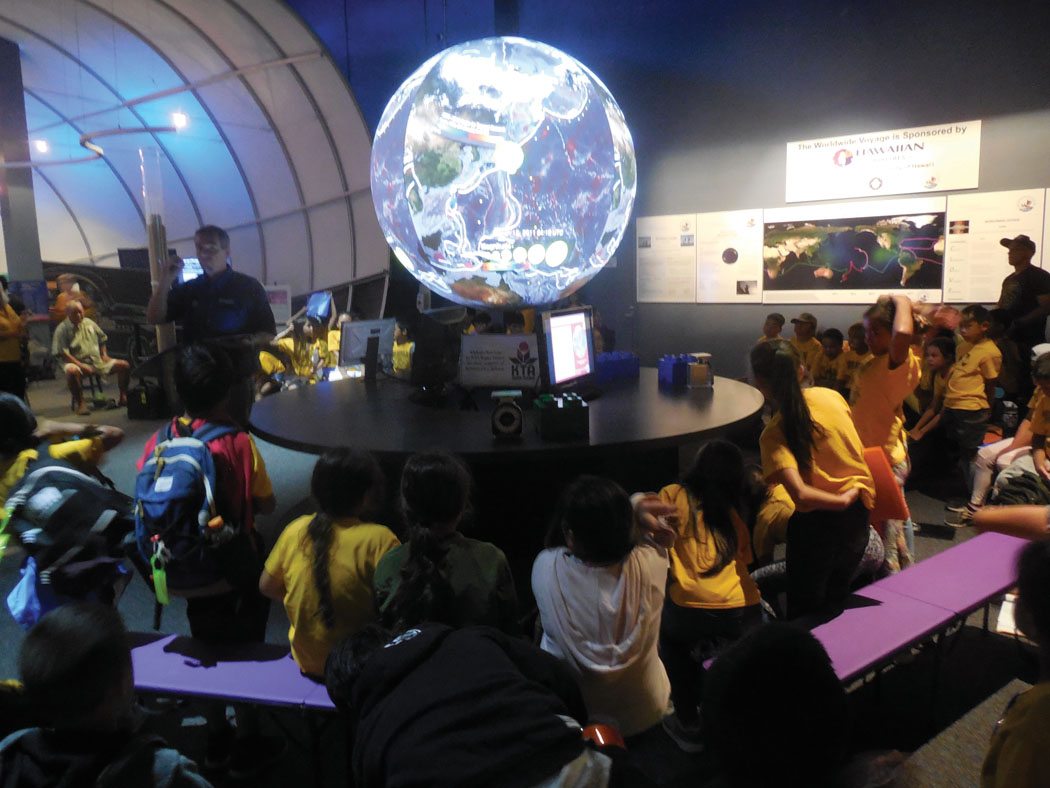
One of ‘Imiloa’s most striking visuals is its Science On A Sphere (SOS) installation—a product of National Oceanic and Atmospheric Association (NOAA) data and engineering. SOS is a room-sized display system using computers and video projectors to display planetary data on a six-foot diameter sphere suspended above the floor, creating the effect of a massive floating animated globe. A typical SOS field trip session can be heard throughout the exhibit hall as excited schoolchildren shriek wide-eyed at the 9.0 magnitude 2011 earthquake in Japan, which appears on the globe as a swelling translucent bubble sending multicolor time-lapse tsunami waves rippling across the Pacific Ocean.
On the benches encircling the SOS globe and its pedestal, Kālepa Baybayan shares the story of the ocean navigation side of ‘Imiloa.
Kālepa served previously as captain of Hōkūle‘a—Polynesian Voyaging Society’s (PVS) replica of a double-hulled voyaging canoe, known as wa‘a kaulua, which sails using traditional Polynesian navigation techniques. Kālepa has worked at ‘Imiloa since 2009, currently serving as its navigator in residence, developing navigational activities, creating curriculum materials, and doing educational outreach work in schools statewide.
Over the course of his life, Kālepa has witnessed the renaissance of Polynesian navigation, from the time of Hōkūle‘a’s first voyage nearly 50 years ago when only a handful of people could still navigate at sea using the ways of the ancient ones. “I think, coming from the fact that in 1976 we didn’t have any of this knowledge, it means we’ve come a long way in understanding our connection to the past,” Kālepa says.
That connection was saved by a young inspired generation of PVS members like Kālepa, curious about the ancient Polynesian navigational techniques known as “wayfinding.” All those years ago, they tracked down the Satawalese Master Navigator Mau Piailug in the Caroline Islands in Micronesia, and asked him to share his knowledge so that it might avoid extinction. Mau, Kālepa says, was his first traditional wayfinding teacher. “I think it’s important for young people to find a connection like that to inspire their lives,” he says. “Just by DNA you inherit some of those traits, and you need to recognize the successes of those people who came before you, and be inspired by them.”
Polynesian wayfinding is based on observation and memorization, using markers in the surrounding ocean environment such as positions of the sun, moon and stars, the direction of ocean swells, groupings of clouds—even bird flight patterns—as navigational cues. Memorizing the place on the horizon where individual stars rise up into and fall down out of the sky (called “houses”), along with their corresponding cardinal directions at these moments of easterly entry and westerly exit, allows wayfinders to maintain a straight course across the ocean, following rising star to rising star, or falling star to falling star.
Scientific concepts expressed in real-world, easy-to-grasp ways like this, Punawai says, is what makes ‘Imiloa such an engaging place. As the center’s educational programs coordinator, he says it’s all about putting on an exciting show for students so some of the underlying science sticks. “I’m absolutely trying to create memories here,” he says. “How do you engage them? How do you have them leave here excited about learning? Bewilderment: that’s one of things we want to see. Also getting them to talk to each other about what they’re learning.”
In the end, the educator says, he wants students to walk away from his presentations and ‘Imiloa’s exhibits stoked about their future studies of the physical world.
“We want to give them the skills they need to get to the next level,” he says, “to help them become scientists.” ❖
“Fantastic Bugs and Where to Find Them”
Camp ‘Imi-Possible proudly presents “Fantastic Bugs and Where to Find Them”—a week-long program that takes campers on an insect-igation of Hawai‘i’s curious creatures and their habitats! Young scientists will explore Hawai‘i’s endemic insects and spiders—our not-so-creepy crawlies that are found here and nowhere else in the world. On this camp adventure they will also discover mimicry, locomotion, and adaptation through inquiry, investigation, and engineering! Camp will take them on an adventure to the furthest corners of Hawai‘i to observe Maunakea’s famous wēkiu bug, follow the lifecycle of the Kamehameha butterfly, and navigate why our cave-dwelling insects and spiders have lost their sight, just to name a few. Filled with hands-on activities, games, and STEM-based art projects, this camp is sure to engage. Hawai‘i is home to a spectacular array of spiders and insects…if you know just where to look!
For Grades Kindergarten to Fourth Grade
July 22–26th, 2019 from 8am–3:30pm (Early Drop-off/Late Pick-up: 7:30am–4:15)
For more information: imiloahawaii.org
Stefan Verbano
Stefan is a writer, musician, world traveler and farmer living in the jungles outside Kapoho in East Hawaii Island. He holds a B.A. from the University of Oregon School of Journalism and Communication in news editorial and magazine journalism, and is a Returned Peace Corps Volunteer, Zambia (2012–14). When not picking his banjo or juicing sugarcane, Stefan is learning to surf, tending to his fruit trees, hiking out to newly forged lava beaches, riding his motorcycle, or doing research for a Ke Ola Magazine article! He is from the San Juan Islands in northwest Washington, and has worked for the magazine since 2018 when he got his start covering the 2018 Lower Puna Eruption.