On Hawai‘i Island You Can Pick The Weather You Want

By Walter Dudley
One reason Hawaiʽi is known around the world as paradise is that the climate across our island chain is about as perfect as any place on Earth. But what many people don’t realize is that Hawaiʽi Island is the global champion when it comes to the variety of different climates on one island. Back in 1866 when Mark Twain rode across the flank of Mauna Kea from Hilo to Kawaihae, he wrote “snow and ice clasped its summit like a claw…and one could see all the climes of the world at a single glance…” According to the 1884 Koppen Climate Classification System, Hawai‘i Island has 10 of the 14 climate zones on Earth. Basically, you can pick the weather you want and drive there on Hawaiʽi Island.
Hawaiʽi also has some of the lowest variability in climate throughout the year. Lying in the middle of the Pacific Ocean, far from continents, keeps day to day and month to month changes very small. Also, being in the tropics means that the difference in the length of days from winter to summer is less than two-and-a-half-hours in Hilo, whereas in Seattle, the winter—summer difference is more than seven-and-a-half hours. Instead of the four seasons in a year that they have on the mainland, here we have only two: hoʽoilo: the cool season (generally October to March), with a lower sun, more rain, and more variable winds; and kau: the warm season (generally March to October), with the sun high overhead and steady trade winds.
We do have day-night (diurnal) differences, and Hawaiʽi Island is again the champion with the most extreme diurnal weather pattern across the islands. For example, Hilo airport recorded 127 inches of rainfall in 2021, continuing to hold the title as the rainiest city in the US. Yet, solar water heaters and photovoltaic panels work just fine in Hilo because the maximum rainfall is at night with minimum clouds and rain during the day when the sun is brightest.
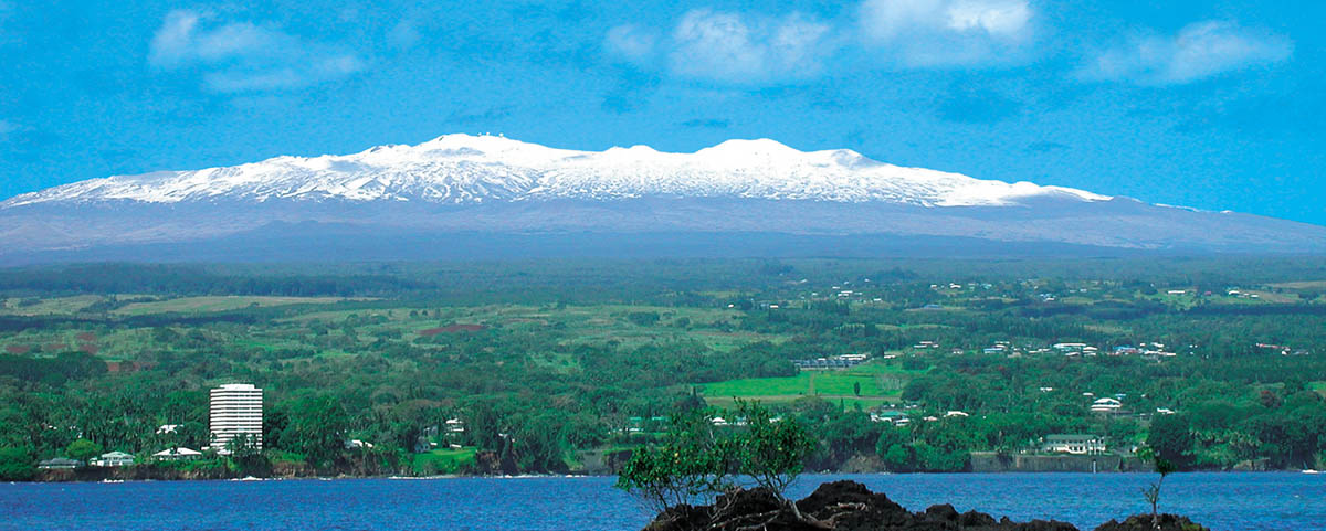
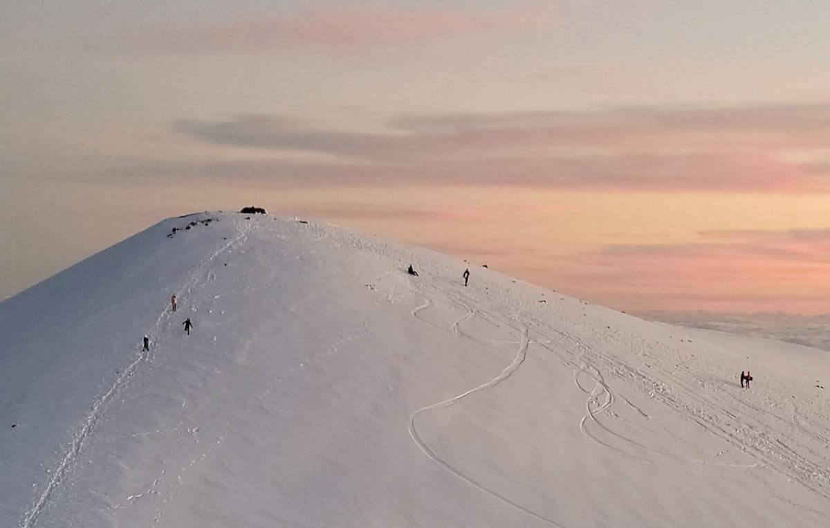
With so few changes from day to day and throughout the year, why do we have so many different climates on Hawaiʽi Island? We can thank the māuna (mountains) for giving us this great climate diversity and the resulting ecosystems that range from tropical rain forest to alpine tundra and even desert—all within an hour’s drive. As you drive from Hilo up Daniel K. Inouye Highway (aka Saddle Road), the temperature drops as much as five degrees fahrenheit for every 1000 feet you climb, going from nice and warm at sea level to near freezing on the summits of Mauna Loa and Mauna Kea at almost 14,000 feet high. It is not unusual to see snow atop Mauna Kea and even Mauna Loa, and some people sled or even ski when the summit is covered with snow.
Rainfall
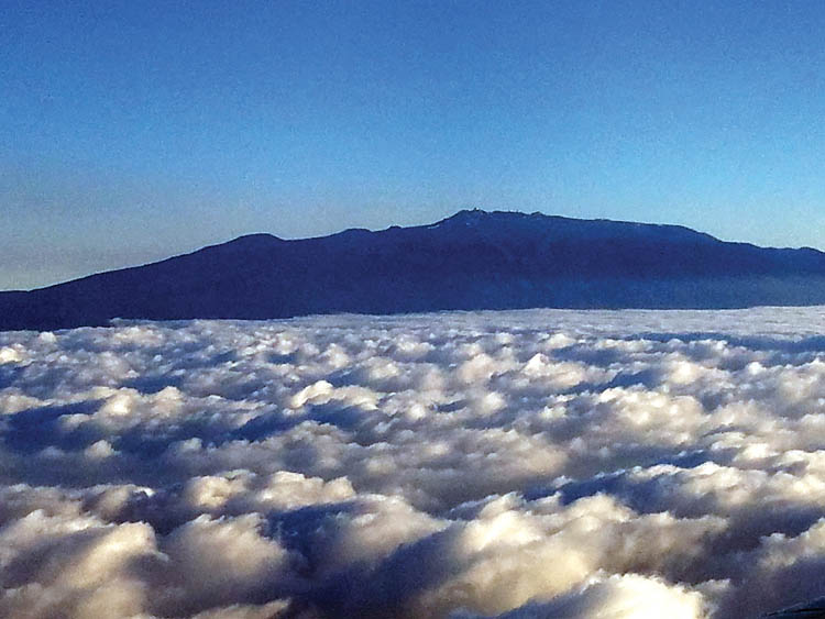
It’s not just the temperature that changes as you drive across the island, the change in rainfall is dramatic. As you drive up above Hilo, rainfall increases to some 300 inches per year, but then begins to suddenly fall off at higher elevations, leaving the upper slopes very dry and usually cloudless. Why do we have this rainfall pattern on the windward or so-called “rainy” side? It’s mostly caused by something known as “orthographic rainfall.” As the trade winds blow across the ocean, sunlight causes water to evaporate. When the moist air hits the slopes, it is forced to rise, forming clouds, and as the clouds continue to rise up the mountain slopes and the air cools, the clouds can hold less and less water, causing it to rain. It’s kind of like squeezing a sponge, which eventually runs out of water. Notice in the photo that the clouds stop abruptly, not little by little.
As the clouds rise to cooler and cooler elevations, suddenly they hit warmer air. This is a relatively thin layer called the “inversion layer.” The winds now blow around the māuna and not over them, with little moisture left for the dry side, leaving the leeward side clearer and dryer—a perfect place for beach goers.
Above the inversion layer on the western slope of Mauna Kea, about an hour’s drive (~40 miles) east of Kailua-Kona, and an hour’s drive (~45 miles) west of Hilo, lies Puʽu Laʽau where the humidity is so low that there is a “dry forest” area. But the Kona side does get some rain as all that sunlight heats the ground causing air to rise, not only creating the inversion layer, but bringing onshore winds with moisture. They often get afternoon rain on the slopes and hence a perfect environment to grow some of the world’s best coffee.
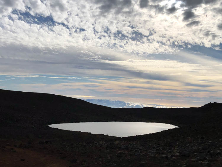
The many climates of Hawaiʽi Island have changed over time. If you look across the saddle from Mauna Loa to Mauna Kea another mystery presents itself. There are numerous strange looking rock formations not typical of volcanoes. These are left over from the Ice Age. Yes, there were glaciers atop Mauna Kea, some going back 200,000 years and others formed as recently as 13,000 years ago. You will see weird scratches on the lava created as rocks were dragged by glaciers over ancient lava flows. As you drive by Mauna Kea County Park in the Pōhakuloa region, you will see deep gulches that were carved out by these glaciers. Also, when the ice melted it left boulders, called “erratics,” sitting isolated as if they fell off the back of a dump truck. Much of this former glacial area has been protected as the Mauna Kea Ice Age Natural Area Reserve and includes Lake Waiʽau, one of the highest lakes on Earth at 13,020 feet elevation and sitting in a shallow depression once filled with ice, also of great cultural significance to Native Hawaiians.
Lava erupting under the ice also produced an extremely dense form of basalt lava rock which was perfect for making stone tools, especially for “adzes”—the blades used for cutting before metal arrived in Hawai‘i. The reserve includes the site of the world’s largest rock quarry for making adzes.
Looking across from Mauna Kea to Mauna Loa is another amazing site that has recorded world records. Hawai‘i Island is home to the oldest lab established to measure changes in carbon dioxide on our planet—the Mauna Loa Observatory. In 1956 NOAA set up a scientific laboratory to “observe” and monitor the amount of various gases in the earth’s atmosphere. The site on Mauna Loa, at 11,500 feet elevation, was chosen due to its location above the inversion layer, to avoid any locally polluted air, and measure samples of well-mixed air from the upper atmosphere. It was the first and remains the oldest station on Earth, measuring the composition of the earth’s atmosphere. What they have discovered over the years is what continues to make headlines in the news around the world—it is getting warmer across the planet, with record heat being recorded everywhere from England to the Italian Alps to China and India. The cause and effect are clear—the amount of carbon dioxide in the atmosphere has risen from less than 320 ppm (parts per million) in 1958, when detailed measurements began on Mauna Loa, to over 400 ppm today—a 25% increase in less than 65 years, a mere blink of the eye in geologic time. Alas, everything is changing way too fast.
Surfing and Other Water Sports; Many Options
Not only can you drive to the weather you like, but also to where surf is breaking. Our position in the middle of the Pacific not only gives us mellow weather, but it makes Hawai‘i the best surfing location on earth. Portugal may get the biggest waves ever surfed so far, but here we can pretty much always find breaking waves to surf. In fact, you can go surfing and diving pretty much year-round, but exactly where changes with the season. Breaks on the northwest to northeast shores typically occur during winter when strong winter winds in the northern hemisphere create swells that travel down to the islands. Our northern hemisphere summer is winter in the southern hemisphere and strong winter winds there create swells that break against our southern (southwest to southeast) shores. So, surfing gets shared around the island, and this is also good for diving and fishing as calmer water on the opposite side of the island from the breaking surf creates safer diving and fishing conditions with clearer water. It’s a win-win.
Rainbow Capital
Our amazing weather has also helped Hawai‘i earn the title as “Rainbow Capital of the World.” There are many Hawaiian words for rainbow, ranging from “anuenue,” to “punakea” (barely visible rainbow) to “kahili” (rainbow shaft) to “anuenue kau pō” (moon rainbow—yes—you can also see those on Hawaiʽi Island). When Mark Twain visited Hawai‘i, he remarked that rainbows were “as common in the islands as fog and wind in San Francisco.” Lucky we live Hawai‘i! ❖
Reference: Atlas of Hawaii, edited by Sonia P. Juvik and James O. Juvik, Chief Cartographer: Thomas R. Paradise, third edition, 1998.