The Road to Recovery Began with a Road
By Stefan Verbano
A side of the perched lava channel fed by Fissure Eight collapses, sending a river of pāhoehoe barreling northeast through Leilani Estates toward Puna Geothermal Venture (PGV). By the evening of May 29, 2018, the breakout flow has crossed Pohoiki Road, covered two capped PGV thermal wells, and cut off Highway 132, starting a frantic evacuation of Kapoho. In a scene reminiscent of the darkest days of the Dust Bowl, jalopies and pickup trucks loaded to impossible heights with every conceivable hodgepodge of household items—beds, tables, chairs, couches, lamps, refrigerators, TVs, stereos, dressers, solar panels—roll in slow procession to safety down the one-lane coastal Government Beach Road, now the only escape route for hundreds of soon-to-be-trapped households.

Sedans with furniture ratchet-strapped to their roofs, pickups pulling trailers of terrified farm animals, rented box trucks barely clearing the low-hanging branches of ancient mango trees lining the hastily paved road that just days prior had been gravel, all driven by shaking hands wiping away beads of sweat and welling tears. These are the eruption’s last evacuees, watching with heavy hearts as their homes disappear from sight in rear-view mirrors.
At mid-day June 2, the flow from now-enormous Fissure Eight was miles long, with its pioneering lobe within 100 yards of “Four Corners” where Highways 132, 137, Government Beach Road and Cape Kumukahi Lighthouse Road all intersect along the Kapoho coastline. This crossroads was the last access to the subdivisions of Vacationland, Kapoho Beach Lots, and Kapoho Farm Lots, all of which would be destroyed over the next month, save for a few surviving structures in a small sliver of spared land parallel to the lighthouse road.
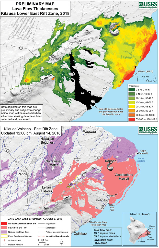
By the time the vast expanse of lava entering the ocean crept south and inundated Ahalanui Beach Park (locally known as “Warm Ponds”) and Kua O Ka Lā Public Charter School on July 12, the 2018 Lower Puna Eruption had covered 8,000 acres, destroyed 13 miles of public roads, created 650 acres of new land along the shoreline, leveled 700 homes and left 110 standing but inaccessible due to road loss. It had forced the evacuation of 3,000 lower Puna residents and created an elaborate checkerboard landscape of kīpuka (untouched land within a lava bed).
The Road to Recovery
The largest of these spared areas was the “Highway 132 Kīpuka,” comprised of approximately 56 properties and 70 still-standing residences. Displaced lower Puna residents with unscathed houses and farms inside this large cut-off tract of land had been without a convenient, safe route home for more than a year and half. In December 2018, tenuous access came with PGV’s grading of a rough gravel road atop the lava channel across its property, with a small offshoot connecting further back roads, eventually linking up with the surviving 1.9-mile stretch of old Highway 132 located inside the kīpuka.
This “PGV Road” came as a joyous relief to the kīpukaʻs evacuees. By signing a waiver and entering at specific times of day, they could at long last access the highway and see their land again. But this special arrangement wasnʻt without its drawbacks: the road was one-lane and bumpy, too narrow to accommodate opposing traffic, often with poor visibility as the lava fieldʻs residual heat turned falling rain into thick, billowing pockets of steam. Residents had to negotiate a 24-hour manned PGV checkpoint, which could deny access if road conditions were deemed unsafe. Power in the kīpuka had long since been out, and basic residential services like mail delivery, public transportation, and fire/medical emergency response were impossible.
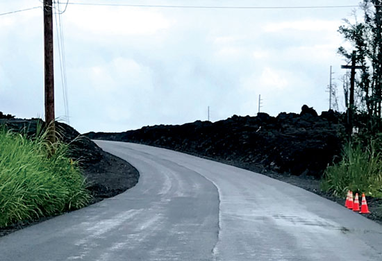
County of Hawai‘i officials, including Mayor Harry Kim, emphasized the importance of reopening Highway 132 from early on. Mayor Kim directed the County to wait six months after Hawaiian Volcano Observatory lowered its alert level for Kīlauea Volcano before beginning any major infrastructure repair work—a postponement that ended last April. Kim has called the highway recovery a “number one priority,” and expressed confidence that the project’s construction costs would be fully reimbursed by the federal government, which they will.
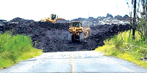
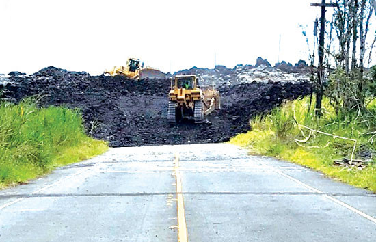
After months of negotiations between Hawai‘i County Department of Public Works (DPW) and Federal and State Departments of Transportation stakeholders, on June 10, 2019, bulldozers started preliminary clearing of the 3.2 miles of covered highway on either side of the kīpuka: a 1.6-mile upper portion from PGV’s checkpoint to the kīpuka’s western edge, and a 1.5-mile lower portion from the kīpuka’s eastern edge to Four Corners. The project also involved the clearing, grading, and paving of a 0.2-mile segment of inundated Government Beach Road from Four Corners north to the edge of the lava flow, as well as brush clearing, striping, and signage/marking installation along the segment of surviving old highway within the kīpuka.
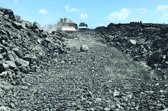
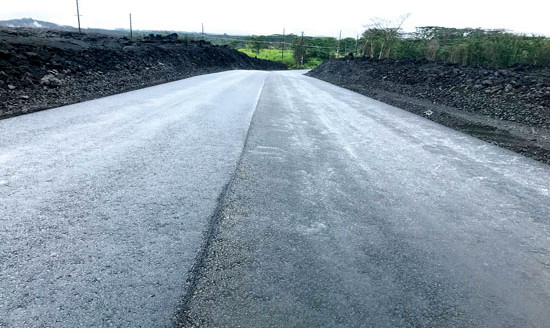
The contractors worked diligently, battling hundred-foot-thick lava hills, hazardous undersurface voids and pockets of extremely high heat—some crews encountered 800-degree rocks, which for a time halted progress of the lower portion. Though the County is calling the repaired segments a “temporary road,” the new highway will function just like the old one. It will have an identical alignment and design speed, with the same dual travel lanes and shoulders as its pre-eruption state.
According to County officials, much of the input they received from affected residents in the wake of the disaster involved how important Highway 132’s reopening was to the recovery of the area.
“The County has received tremendous community feedback from those who live in lower Puna and whose lives were directly impacted by the loss of Highway 132 to reopen this crucial thoroughfare so that residents can return to their homes and businesses,” says DPW spokeswoman Denise Laitinen. “Big Island residents with homes and farms that have been landlocked by lava have voiced great relief about being able to once again reach [them].”
Beyond just benefitting the kīpuka residents themselves, the reopened highway will improve access for hundreds of people living outside the lava area whose normal routes were still severely limited in the eruptionʻs wake. It will reduce traffic congestion in other neighborhoods, too, whose roads have long been used as detours, namely Kahakai Boulevard in the Hawaiian Beaches/Shores subdivisions.
“Restoring Highway 132 will greatly reduce the amount of time and distance area residents need to travel to Pāhoa,” Denise says, “improving their overall quality of life, reducing emergency response time and minimizing impacts on neighboring subdivisions which have been providing alternate routes since the beginning of the lava event.”
Looking Forward
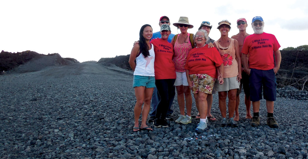
Nancy Seifers used to live in what is now the Highway 132 Kīpuka at mile marker 5.5, in a home down a dirt road off the highway in a neighborhood of about a dozen others homesteads. She would commute 12 minutes to work as a schoolteacher in Pāhoa. The flow took out 100 fruit trees and her property’s original farmhouse, yet left a newer structure standing. During the period when the only access to the kīpuka was through PGV’s primitive access road, it took Nancy 45 minutes to get from her home to town. With the renovated highway finally open in late November 2019, Nancy plans to move back into the surviving house and begin putting the pieces of her former life back together.
“By our own devises, we’ve managed to start our own recovery,” Nancy says about residents in the isolated areas. “All we ever really needed was the roads. They’re imperative. If we got our roads…all the farmers could get their goods to market. We’d be thriving again.”
Of her own 257 acres on the summit and slopes of Green Lake Mountain (Kapoho Crater), local resident Smiley Burrows lost 100. Smiley is an avid farmer, perhaps best known before the eruption for running her weekly fruit stand along Highway 137 across the street from Kapoho Beach Road. Avocado orchards, livestock pasture, banana groves, and monkey pod forests made up part of her consumed land. “We pretty much lost every fruit tree I planted for 20 years,” she says.
Smiley is optimistic about the recovery of the area, though. With the highway open again, she too has her sights set on moving back into a surviving structure and working to make the land—whether covered in lava or not—productive again.
“There’s a lot of opportunity to replant. I’m definitely into regrouping, replacing anything. We have lots of cinder now, hah!” she says.
“We look at the losses and the tragedies of this experience…I lost a lot…you know, houses and this and that,” Smiley says. “But [during the flow] I was up on top of my ladder every night just in awe of creation, of having the opportunity to actually witness it, and I honor it. So this new land to me is beautiful and we need to recognize that thatʻs part of our choice of living on the Big Island: acceptance of new land forming. If you want to live here, you have to live that reality.”
This seems to be the sentiment of many residents—eternal optimism reigns, because people who choose to live in Puna are resilient. After all, Puna is strong! ❖
For more information: recovery.hawaiicounty.gov
Stefan Verbano
Stefan is a writer, musician, world traveler and farmer living in the jungles outside Kapoho in East Hawaii Island. He holds a B.A. from the University of Oregon School of Journalism and Communication in news editorial and magazine journalism, and is a Returned Peace Corps Volunteer, Zambia (2012–14). When not picking his banjo or juicing sugarcane, Stefan is learning to surf, tending to his fruit trees, hiking out to newly forged lava beaches, riding his motorcycle, or doing research for a Ke Ola Magazine article! He is from the San Juan Islands in northwest Washington, and has worked for the magazine since 2018 when he got his start covering the 2018 Lower Puna Eruption.