Kea‘au, A Point in Time
Compiled by Peter T. Young and Barbara Garcia
‘Ōla‘a or Kea‘au?
What happened to ‘Ōla‘a? That seems to be the question for some, because in the district of Puna, what once was called ‘Ōla‘a is now called Kea‘au.
Forests once covered much of ‘Ōla‘a—from 1905–1928, they composed part of the forest reserve system within the islands. The forestlands of ‘Ōla‘a were noted for their growth of ‘ōhi‘a and koa trees, and hāpu‘u tree fern.
At the Mahele in 1848, ‘Ōla‘a was retained by the Crown. It was described as “A very large land, but cut off from the sea by Kea‘au” (Cultural Surveys).
Kea‘au includes about 60,000 acres of land and is the northernmost of some 50 ahupua‘a (ancient land divisions) found in the district of Puna. Kea‘au extends from the ocean fishery to approximately 26 miles inland, and reaches an elevation of about 3,900 feet. Portions of it wrap around the makai (ocean-side) point of ‘Ōla‘a.
Historically, people typically settled along the shoreline. In this sense, Puna is not typical because much of its coastal areas have thin soils, and there are no good deep-water harbors, so settlement patterns in Puna tended to be dispersed and without major population centers. Villages in Puna were built inland, away from the coast, where the soil is better for agriculture (Escott).
What is consistent and clear from testimony before the Land Commission: there definitely was an ‘Ōla‘a in upper Puna. The testimony is equally consistent and clear that there also was a Kea‘au. Thomas G. Thrum, in his 1894 Hawaiian Almanac and Annual, noted, “The year 1894 witnessed the completion of the volcano road which was begun in 1889. This is a boon to visitors and the settlers in the new coffee district of ‘Ōla‘a, as it affords a fine carriage drive the entire distance of thirty miles. Regular stages now run between Hilo and the Volcano House every other day.”
In many historical websites and books, it is commonly referenced this way: “Ōla‘a is on the Hilo side of the road and Kea‘au on the Puna side.” Others phrase it, “Ōla‘a being on the North side of the road and Kea‘au on the southeast side.” Thomas Thrum wrote, “Ōla‘a has come into prominence in the past few years as a most promising coffee center. The opening of the road from Hilo to the volcano, which traverses this neighborhood, was the means of bringing the possibilities of the Ōla‘a lands to public notice as well as within reach” (1898).
Before 1900, coffee was the chief agricultural crop in the ‘Ōla‘a area. Approximately 200 independent coffee planters and six incorporated companies owned more than 6,000 acres of coffee trees.
Soon, sugarcane was in large-scale production. Initially founded in 1899, Olaa Sugar Company leased about 4,000 acres of land, expanded, and eventually became the dominant operation in the region. Plantation fields extended for 10 miles along both sides of Highway 11 between Kea‘au and Mountain View, as well as in the Pāhoa and Kapoho areas.
Construction of the centrally located ‘Ola‘a Sugar Mill was completed in 1902, requiring 51 men working a three-shift operation. This industrial expansion marked the beginning of massive landscape alterations and clearing operations. A community grew around the plantation. Attention to employee welfare was demonstrated by ‘Ola‘a Sugar Company’s housing program, free medical attention, and recreational facilities. ‘Ola‘a modernized employee housing by building new family units, and relocating outlying houses scattered about the plantation into nine main villages.
Those villages became miniature towns with running water, electricity, schools, churches, stores, clubhouses, theaters, parks, and ball fields. The plantation roads radiated from the villages to cover the cane areas where the men worked. The 1930 plantation census noted a total of 5,999 men, women, and children residing in 1,098 houses at ‘Ola‘a (HSPA).
The plantation made land available for community uses. As examples, the ‘Ola‘a Hongwanji was built in 1902. ‘Ola‘a School, an elementary school, began in 1939. Other groups and places were formed using the ‘Ola‘a namesake.
Without clear documentation to explain, The Friend newspaper reported that on April 10, 1951, the ‘Ola‘a Christian Church changed its name to the Kea‘au Congregational Church.
In 1960, ‘Ola‘a Sugar Company became Puna Sugar Company. ‘Ola‘a Elementary School became Kea‘au Elementary and Intermediate School (later Kea‘au Middle School). In the early 1970s, ‘Ola‘a Hongwanji became Puna Hongwanji. Not all early labels and references were incorrect; a 1914 USGS map appears to correctly label the place once known as ‘Ola‘a, as Kea‘au.
Forming of the Village
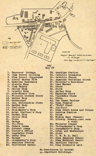
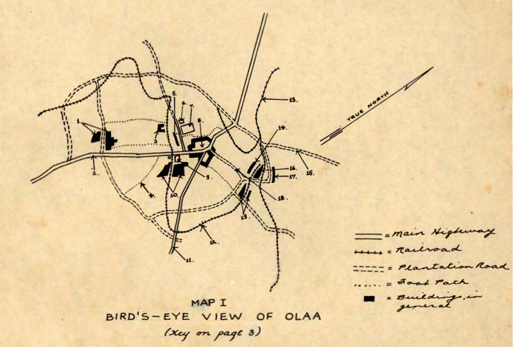
According to localciting.com, a paper was written in 1937 called “The Ecological Study of the Community: The Keaau Village (Olaa),” by someone referenced as C.T., for an introductory sociology class. “C.T.’s paper is an ‘ecological study’ of Kea‘au village, which was commonly known as Ōla‘a village. What makes C.T.’s work exceptional is the number of maps—seven in all—with their keys—and the exquisitely rendered details they provide. The first map offers a ‘bird’s eye view’ that highlights Kea‘au’s major landmarks and transportation network.”
The paper goes on, “The main plantation buildings and structures are in proximity to the village, as well as roads, footpaths, and railroad lines that service both the plantation and village. Although the focus of the paper is on the village, C.T. devotes the first three maps and half the paper’s narrative to the entire plantation-village complex. Because of the plantation camp’s system of roads and footpaths, workers had easy access to the village. The writer also notes, with apparent pride, the centrality of the village: ‘It is interesting to note in Map I that the village enjoys a central position. The mill occupies a secondary position in the scheme of the Ola‘a community.’”
“Of the several maps offered here, this map—Major Social Institutions in Village—brims with details and clearly illustrates the economic condition of the village in the late 1930s. Although the writer asserts that trade is still at the elementary stage and the village remains dependent on the plantation, what he describes is a growing and bustling community. The map key lists sixty-three ‘institutions’ in the village, including central government and community services functions: the courthouse and prison (number 49), library (53), school (2) and community hall (63), as well as a branch office of a bank (52) and a doctor’s office (26).”
More History
A historic trail once ran from the modern day Lili‘uokalani Gardens area to Hā‘ena along the Puna coast. The trail is often referred to as the old Puna Trail, or Puna Road. There is a historic trail/cart road that is also called the Puna Trail (Ala Hele Puna), or the Old Government Road (Escott).
It likely incorporated segments of the traditional Hawaiian trail system often referred to as the ala loa, or ala hele. The full length of the Puna Trail, or Old Government Road, might have been constructed or improved just before 1840. The alignment was mapped by the Wilkes Expedition of 1804-41 (Escott).
With Western contact, extensive tracts of Puna’s landscape were transformed, first with sandalwood export, which began in 1790 and reached its peak between 1810 and 1825 (Puna CDP).
‘Ōhiʻa forests also had to be cleared, field rock piled, land plowed by mules or dug up by hand with a pick. Soon, sugarcane was in large-scale production. The dominant operation in Puna was the Puna Sugar Company, whose plantation fields extended for 10 miles along both sides of Highway 11 between Kea‘au and Mountain View, as well as in the Pāhoa and Kapoho areas. The sugar mill operation ran for just over 80 years, until 1984.
Macadamia nuts and papaya were introduced in 1881 and 1919. Since the closure of the Puna Sugar Company, papaya and macadamia nut production have become the leading crops of Puna. About 97% of the state’s papaya production occurs in Puna, primarily in the Kapoho area, or at least it did until the 2018 lava flow covered much of Kapoho and destroyed many of the farms.
Another thing growing in Puna is housing and commercial buildings. Between 1958 and 1973, more than 52,500 individual lots were created. Current statistics state it is the quickest growing area in the state. Along with the housing boom comes the elimination of agricultural lands, and sometimes small “mom and pop” shops have to make way for other businesses whose management sense the potential for growth. Such was the case 25 years ago when a small shopping center was razed to make way for a fast food restaurant and gas station, and again recently when the Kea‘au Farmersʻ Market complex had to relocate for a chain store to be built.
Just like its two names, some call this progress; others call it an era gone by. Whatever it’s called, one thing everyone can agree on is the beauty of the Kea‘au and ‘Ōla‘a areas still remains. ❖
For more information/Resources:
imagesofoldhawaii.com
localciting.com