Then & Now: Ka‘u Landings
 By Pete Hendricks
Mauna Loa Volcano had almost taken its present form when the first Polynesians began to fish, live, and farm in the Ka’ū District. The Ninole Volcanic Hills, seen above Punalu‘u, date from eruptions long before Mauna Loa and may be some of the oldest blocks in the ancient fault system.
The two primeval volcanoes began forming the island of Hawai‘i as it rose from the deep sea floor about a million years ago, breaking the ocean surface 500,000 years ago. The first recorded people came to the flanks of the slightly older volcanic mass, Ninole, and by the time Polynesian voyagers arrived, Hawai‘i Island was composed of five volcanoes. The next island, Lō‘ihi, was already growing in the deep ocean over a hotspot a few miles to the southeast, and will some day be the youngest island in the Hawaiian chain.
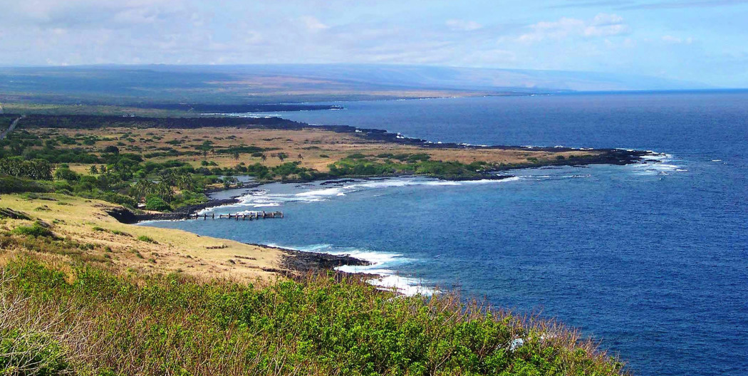
The new residents found a wild, primal land along the seacoast stretching toward Ka Lae (South Point), with almost constant, robust wind sweeping across the southernmost tip of all the islands. The prevailing northeast winds still blow there and continue up the leeward coast as far as Kauna Point, over 15 miles toward Kailua-Kona.
The district of Ka’ū is physically larger than the island of O‘ahu. The present Hawai‘i County Council District stretches from Kupapau Point at Hawai‘i Volcanoes National Park all the way around to Kealakekua Bay. But the heart of Ka‘ū fronts the southeast coast. Long before Hawaiians organized into ahupua’a and other island divisions, before a united Hawaiian Kingdom, the first Polynesians arrived. Bringing their culture, knowledge and basic materials for survival, the voyagers immediately began fishing and farming.
Only after the mid-1900s has technology allowed us to recreate a chronology for the earliest settlers. Until the 1950s, Hawaiian archeology was composed of surveys of stone structures and localized collections found on the surface. The discovery of radioactive carbon dating of charcoal was a new key to early sites. Analysis of early Hawaiian camps, homes, and fireplaces, including Pu‘u Ali’i, at Ka Lae, indicated Polynesians had arrived and lived there for many generations, perhaps back as early as 300 AD.
In the 1780s, Keoua Ku’ahu’ula, ruler of the district of Ka‘ū, was the chief rival of Kamehameha I for control of the island of Hawai‘i. That rivalry, which ended with Keoua’s death, could have gone either way, but history knows Kamehameha as the eventual ruler of all the islands.
Along the entire shoreline of Ka‘ū, there are settlements which go far back in time, especially Punalu’u, with its abundant water flowing seaward from Ninole Gulch. The Ka‘ū district is isolated from other districts by lava flows, prevailing winds, and the Mauna Loa massif. It is a “downhill” sail by sea (with the wind at your back) westward along the coast from Cape Kumukahi to La Lae, but usually a struggle under sail or power into the northeast “tradewind” back toward Hilo. Hawaiian coastal mariners paddled and sailed regularly along the coast for centuries, traveling and fishing in Ka‘ū communities that were somewhat isolated by distance and climate from the outside into the mid-1800s.
Reverend William Ellis, in his circuit around the island in 1823, estimated Ka‘ū’s population at 5-6,000. A government survey in 1853 put the population at 2,210, a 50 percent drop in 30 years, with diseases taking their toll as they did elsewhere in Hawai‘i.
After the Great Mahele land division of 1843, more foreigners acquired land and began western agricultural businesses. In 1860, ranching gained momentum in Ka‘ū, with the start of Kapapala Ranch, and in 1866 with Kahuku Ranch, managed by a former whaling captain named Robert Brown. The vast grazing lands of Ka‘ū district seemed ideal for the cattle business.
Then, all of a sudden, all of Ka‘ū and the entire island began to shake in March of 1868 with a swarm of massive earthquakes that also caused a tsunami. At the same time, both Mauna Loa and Kīlauea were erupting!
At about 4 p.m. on April 2, Mrs. Sara Joiner Lyman noted in her diary, written in Hilo, 40 miles away from the worst shaking, “There was such an awful rocking and heaving of the earth as we never felt before…. At one moment the surface of the earth seemed to move like the surface of the ocean and the large trees to sway hither and thither like ships’ masts in a storm…. The shocks were considerably more severe here than they were at the crater of Kīlauea 30 miles from here, but less severe than they were in Ka‘ū from Kapapala to Kahuku.”
After the huge earthquake, Captain Brown’s Kahuku Ranch home was covered with lava from a southwest rift outbreak of Mauna Loa. About 250 head of cattle were consumed by the lava. To Ka‘ū residents, those days of continuous strong tremors must have been unnerving.
The 1868 earthquake damage was severe, but the related, locally generated tsunami rose up to 50 feet along the shoreline, drowning many and destroying numerous Ka‘ū shoreline villages and residences.
Many Hawaiian coastal settlements in Ka‘ū just disappeared.
Perhaps even greater change came with the pressure to move people and goods in the new market economy. People regrouped and rebuilt. Along the Ka‘ū coast, four bays were the shipping points for the vast district: Keauhou, Punalu’u, Honuapo and Ka’alu’alu [see map]. All of the bays had been used by earlier Hawaiians, but now more schooners and steamships began to call. Keauhou Bay (not the one in Kona) to windward, being the nearest to Kīlauea volcano, began to host a few hardy tourists willing to make the arduous trek up the mountain to Kīlauea.
The first loss of a western ship in Ka‘ū occurred at Keauhou in 1846, when the schooner Clarion went ashore. Captain Pali and crew were saved, but the cargo was lost. Clarion was likely engaged in the pulu trade—pulu being the soft wool at the base of the hapu’u (tree fern) frond stalk. For a time, pulu was the preferred mattress and pillow stuffing. Up to 50 people were later employed in the pulu operation, harvesting in the volcano forest, and bringing the bales of stuffing by mule down the long trail to Keauhou landing.
Tourist numbers increased with the expansion of Volcano House in 1877. The first Volcano House, now the Volcano Art Center, was hauled piece by piece up the old pulu trail by wagon from Keauhou landing. Later, tourists would take the railroad from Honuapo to Pahala, and complete the Volcano journey by stagecoach.
The southernmost of the four Ka‘ū landings, Ka’alu’alu Bay was used for a time for goods and cattle shipments, and was closest to Wai’ohinu, seven miles upland, formerly the main village of Ka‘ū. As sugar production grew in Ka‘ū, Ka’alu’alu was little used commercially except for cattle shipments.
Punalu’u, and later Honuapo, became the principal landings with the growth of the Ka‘ū sugar industry. The first sugar plantation, Na’alehu Sugar Company, was established by Alexander Hutchinson and John Costa in 1878. By the 1880s, there were four plantations with mills in Ka‘ū, and a number of other sugar growers.
No place in the entire district of Ka‘ū has had a wharf to accommodate vessels larger than lighters or large whaleboats. Even at Punalu’u and Honuapo, both improved by wharfs, ships had to anchor or tie up to moorings, while cargo and passengers made the often dangerous transition from ship to shore in rowed whaleboats, later motorized.
In early sugar days, workers had three- or five-year contracts, and were under bondage to the plantations. The local sheriff would track down “deserters” for return to the plantations. The return of two workers to Honuapo resulted in a local tragedy. Alexander Hutchinson, a pioneer in Ka‘ū sugar, met a steamer off Honuapo landing in 1879 to take custody of two field workers who had deserted. On the way back to shore, the large rowboat carrying everyone capsized and Hutchinson hit his head on the reef, dying a few days later.
The schooner Fanny also met her end on March 2, 1878, at Punalu’u. Fanny, 49 tons, had spent years as a pilot boat at the port of San Francisco, and had been in the Hawaiian coasting trade a short time. Again the sea took its toll, as the little schooner, under an acting captain, apparently anchored too far to leeward in the bay, she was not able to claw away to windward from the reef upon departure.
The precarious business of sending sugar and cattle from Honuapo continued until 1942, when the port was shut down permanently due to World War II concerns. Better roads allowed cargo to be trucked to Hilo for outward shipment. Ka‘ū Agribusiness Company, the last sugar operation on Hawai‘i Island, continued operations until 1996.
The Ka‘ū coast and ocean today continues to be a wild, beautiful, primal place—the longest stretch of undeveloped coastline in the state of Hawai‘i. Fishermen still harvest the rich, nearshore waters and offshore ocean, but going to sea in Ka‘ū—site of the first Hawaiians’ landings—is only for the experienced mariner. ❖
Contact writer Pete Hendricks at oldsaltp@yahoo.com


